iIf you search for Teocalli Ridge on TrailForks or MTB Project, you’ll find glowing five-star reviews calling it “fun” and “flowy,” and my personal favorite—it has “a couple of hills.” What they don’t mention is that those “hills” are actually oxygen-sucking slogs topping out at over 11,000 feet.
Unless you’re a Colorado local with yeti-level lungs and a love for suffering, the real payoff here isn’t the ride—it’s the views. And yes, they’re spectacular, especially in the fall when the entire valley glows gold with changing aspens. But the full Teocalli Ridge loop? It’s pretty brutal but beautiful and if I’m being honest, maybe not quite worth the grind… But that said, it’s also worth doing once.
If you’re planning a mountain bike trip to Crested Butte and have Teocalli Ridge on your list, this post will give you an honest lowdown so you can set your expectations accordingly.
Teocalli Ridge Trail Loop at a Glance
Location: Crested Butte, Colorado
Distance (full loop): 11.1 miles
Elevation gain: 2,210 feet
Elevation loss: 2,210 feet
High point: 11,300 feet
Lung-busting climb, stunning mountain and valley views, and a fast and furious descent
What I like about the Teocalli Ridge Loop
Truly stunning views
Spring wildflowers and golden fall aspens
Fast and fun descent
Camping right at the trailhead
What I don’t
Holy crap that climb…
The fast descent leaves you wondering if it was worth the struggle
Sections could use some trail reworking to make it more rideable (and enjoyable)
Quick Tips
For mountain biking the Teocalli Ridge loop
e-bikes ARE allowed on Teocalli. One of the few trails they are permitted on in CB.
11 miles and 2K of climbing may not sound like much, but don’t underestimate this ride. It’s tough.
Take your time on both the climb and the descent. The first time I rode Teocalli, I bombed down without stopping and it left me feeling like it was not worth the effort. I’m still not sure it is…
TWW Take
Please note that these are my personal opinions – you may argue otherwaaaaise! And if so, state your case (politely) in the comments 🙂
Fun-ness Factor
Trail Variety
Trail Difficulty
Full Loop Difficulty
Preparing for your Teocalli Ridge ride
How to ride it
Unless you have a high clearance 4×4 vehicle to shuttle, most people ride Teocalli as a loop (see the map).
A note about shuttling: You need a Jeep or truck to get far enough up West Creek Branch Rd. to make a shuttle worth it. Even cutting off those few miles, though, won’t cut off much climbing. Honestly, I don’t think attempting a shuttle is worth it.
As a route, the Teocalli Ridge loop is pretty straightforward: climb, climb, climb, and then descend! Here’s a breakdown on what to expect mile to mile.
Miles 0-0.5: Sideshow
This is a short singletrack connector climb trail that was put in more recently— it wasn’t there the first time I rode Teocalli. It basically cuts off a short section of road from the trailhead parking.
Climbing up Sideshow from the parking area
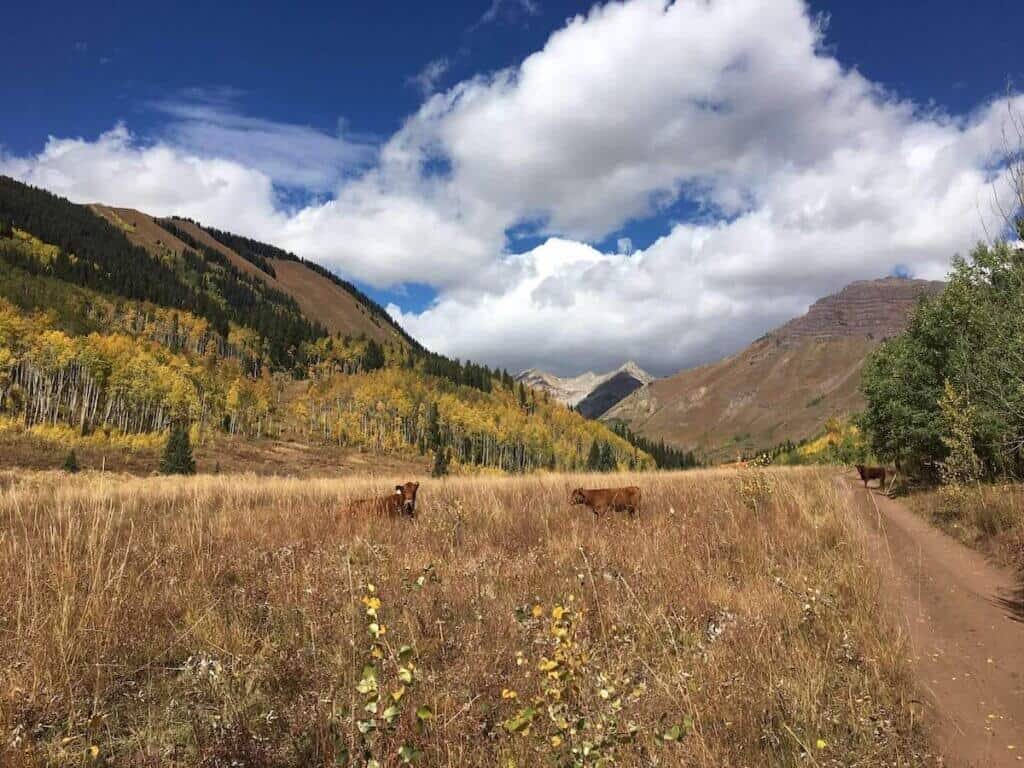
Miles 0.5-4.5: West Brush Creek Rd.
Elevation: Starts at about 9,300 ft and climbs to 10,350 ft before transitioning to Teocalli Mountain Trail.
Terrain: This part of the loop is a mixed bag. After climbing up Sideshow, it’s actually a pretty pleasant pedal along a well-packed dirt road. It’s beautiful and makes you think that this ride might actually be easier than you expected. But once you hit the creek crossing (go left UP the creek, don’t follow the trail into the bushes, although that is the more adventurous way…) things take a bit of a turn.
The road starts to get looser and narrower and steeper. In fact, the last stretch up to the start of Teocalli Mountain Trail is not road at all, but overgrown doubletrack. Don’t be too proud to walk up the steep sections, you’ll need as much leg juice as you can save.
Vibe: It’s beautiful. Even though the majority of this stretch is road or old doubletrack, it traverses along the valley floor through meadows and aspen groves. To the right you can see where you’re headed— up Teocalli Ridge.
Effort: Easy then moderate then hard.
Notes: As I mentioned above, you’ll come to a creek crossing. Go left UP THE CREEK. If you follow the trail, you’ll wind through some pretty ridiculous brush that is adventurous, but harder than just pedaling up the shallow river.
Miles 4.5-5.7: Teocalli Mountain
Elevation: Gain 773 feet in 1.2 miles, ending at just about 11,000 feet (although there’s more climbing to come…)
Terrain: Sidehill climbing at 11K feet. The trail itself is not technically challenging, but it is steep and the altitude doesn’t make it any easier. Kudos to you if you stay on your bike and pedal the whole thing.
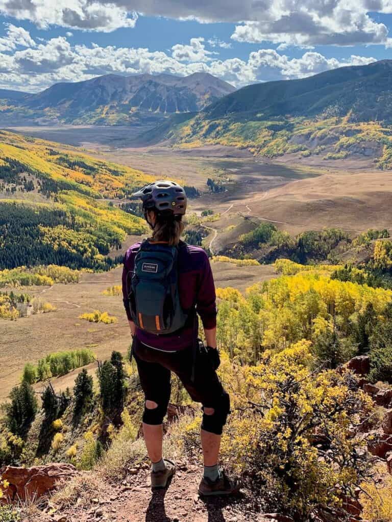
Vibe: So beautiful! Even though you may be regretting your decision to do this ride at this point, you’ll have to admit to yourself that the views are stunning.
Effort: Hard. Very hard.
Notes: I’ve ridden the Teocalli Ridge loop twice now and both times I found myself thinking “is this worth it?” on this section. It’s hard, it kind of sucks, but it’s really beautiful and overall, I do think it’s worth it— at least once.
Miles 5.7-11: Teocalli Ridge
Elevation: Tops out at 11,300 ft
Terrain: After all that climbing on the sidehill traverse, it’s time to go downhill right? Wrong… once you intersect with Teocalli Ridge Trail, you still have about 240 feet of climbing, which doesn’t sound like much, but it’s going to feel like a lot— trust me. There are some mean pitches/hike-a-bikes. I wish they would do some trail work here and add some switchbacks so it feels more manageable.
But once you get to the lookout, you’re in for a great descent! It’s pretty much 4 miles of downhill with everything thrown in: fast flow, chunky rock gardens, tight switchbacks, beautiful views, and even some little kickers at the end.
Vibe: After the last bit of climbing, Teocalli transitions to 4 miles of fun and beautiful downhill. It’s pretty sweet, but the reality check is that it’s over too fast.
Effort: Hard to moderate (I’d say the downhill is a soft black at best)
Notes: Don’t do what I did my first time riding Teocalli Ridge and just bomb down the descent. It’s over in like 10 minutes and you’ll be left wondering whether the 2-hour climb was worth it. Take your time, stop at the view points and make it playful and fun instead of going mach speed.
FAQs for mountain biking Teocalli Ridge
Got questions? I’ve got answers! Here are some helpful tips for planning your ride:
Yes, e-bikes are allowed on Teocalli. This is one of the few trails around Crested Butte they’re permitted on.
Last time I rode it, I did it in 2.5 hours moving time (so a bit over 3 hours total). I’d say give yourself at least 4 hours if it’s your first time riding Teocalli.
Honestly, it’s not that technical for a black-rated trail. There are a few chunky rock gardens, but overall I’d say it’s a spicy blue. What’s most challenging about the Teocalli loop is the climbing and the elevation.
There first few miles are along West Brush Creek, but there is no water along the ridge. (Filter your water— there are a lot of cows that graze in the area).
I’ve ridden Teocalli in both the spring/summer (July) and fall (October). The spring showcases popping wildflowers, but the fall is pretty spectacular with all the changing aspen leaves. If I had to pick, I’d choose fall.
Yes, but this is a backcountry ride with no cell service. Bring your phone with a trail app downloaded – I use TrailForks, but MTB Project is another option.
No. You might get a few bars along the ridge, but don’t expect it. There’s also no cell service at the trailhead.
Yes, “Tent City” is located basically at the trailhead parking. There are about a dozen first-come first-serve sites that are free (you don’t need to be tent camping). There is no running water, no electricity, and no cell service, but there is a pit toilet. These sites are pretty popular and fill up fast, so get there early or be prepared to stake out an pounce on a spot when someone leaves.
Note: I wouldn’t attempt bringing a big RV or tow-behind up here. Small RVs and small trailers are ok.
Need gear recs?
Head over to my gear closet! I’m always testing out new pieces of bike gear and if I really like them, they earn a place on this page.
Teocalli Ridge is not a casual cruise… it’s a lung-busting, leg-burning grind with a descent that’s fast, flowy, and over far too soon. But it’s also undeniably beautiful, with sweeping alpine views that make the suffering a little easier to swallow. It’s a Crested Butte classic for a reason, and while I’m not sure I’d put it on my “must ride every year” list, it’s absolutely worth doing at least once. Just go in knowing what you’re signing up for, bring lots of snacks, and take your time enjoying the few minutes of sweet downhill.
Have you ridden Teocalli Ridge Trail in Crested Butte? What did you think? Is it a ride you’d like to do or does the climbing sound too intense? Leave a comment!
I'm the creator and founder of the bike blog Two Wheeled Wanderer. I’ve been riding bikes and traveling the world since I was a kid and I like nothing more than enjoying some flowy singletrack or embarking on a multi-day bikepacking adventure. When I'm not blogging, I work on multi-month, cross-continent tours with TDA Global Cycling.
I love hearing from you and appreciate your comments! However, if you leave a rude, unconstructive, or spammy comment, it will be deleted. It’s cool to be kind. Have an awesome day!
2 Comments
Totally concur with your assessment in this direction. What a buddy and I found interesting is hiking/riding up the to the drop-in from the classic exit. Sure the initial grunt out of the alpine cabbage is tough but after that, it’s really quite nice. It cuts down the level of effort by a lot and lets you enjoy the descent more.
Agreed! It’s been a few years since I last rode Teocalli Ridge, but your way sounds better 🙂 Check out Dr. Park if you’re still in the area – that was my favorite trail.
Want to know where my two-wheeled travels are taking me? Sign up for my newsletter to get personal updates AND a list of my favorite bike trip planning apps, websites, and more.


Totally concur with your assessment in this direction. What a buddy and I found interesting is hiking/riding up the to the drop-in from the classic exit. Sure the initial grunt out of the alpine cabbage is tough but after that, it’s really quite nice. It cuts down the level of effort by a lot and lets you enjoy the descent more.
Agreed! It’s been a few years since I last rode Teocalli Ridge, but your way sounds better 🙂 Check out Dr. Park if you’re still in the area – that was my favorite trail.