
The Tahoe Flume Trail IMBA Epic Mountain Bike Ride
The 24-mile Tahoe Rim and Flume Trail is the epitome of an epic ride. With amazing views and varied terrain, almost every stretch of this ride is incredibly scenic. There are beautiful meadows, quiet pine forests, and an incredible lookout at Marlette Lake vista. Even the wildflower-lined fire road around Marlette Lake is stunning!
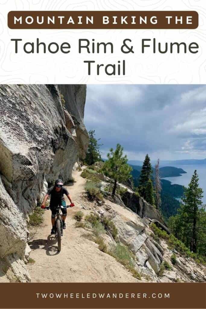
Most impressive, though, is the Tahoe Flume Trail above the shores of Lake Tahoe, which will most likely be one of the most picturesque trails you will ever ride.
So if you’re in Lake Tahoe and looking for a big day out on your mountain bike, be sure to add this ride to your list. It’s an unforgettable experience!
What to know before you ride
You need a shuttle
This is a shuttled ride. Learn more about Tahoe Flume Trail shuttles below.
This is a big day at elevation
Most of the Tahoe Rim & Flume Trail ride is above 8,000 ft. If you’re coming from sea level, you’ll probably feel it. Allow yourself extra time and bring lots of snacks and water.
Water along the route
There are several small river crossings and you’ll pass by the shores of Marlette Lake at about mile 15. Always filter your water before drinking.
Tahoe Flume Trail exposure
There is some hefty exposure on the Tahoe Flume Trail and it may uncomfortable for some people. When in doubt, walk.
Ride on an EVEN DAY
The nine-mile Tahoe Meadows to Tunnel Creek section is closed to mountain bikers on odd days. Make sure you plan to ride this trail on an even-numbered day (for example, July 26th).
Navigating the route
While the loop is mostly well-marked, it is essential that you bring some sort of navigation guide such as TrailForks or MTB Project downloaded to your phone or a printed map.
The Tahoe Rim & Flume Trail Guide
Important! The first section of the Tahoe Rim & Flume Trail is the popular Tahoe Meadows to Tunnel Creek trail. It is ONLY OPEN TO MOUNTAIN BIKERS ON EVEN DAYS. While this is an advisory and not ‘the law’, abiding by this recommendation helps keep the peace between mountain bikers and hikers.
Quick Stats
Tahoe Rim & Flume Trail
ROUTE STATS
- Route difficulty: Intermediate with good fitness
- Mileage: 25.29 miles*
- Elevation gain: 2,110 ft*
- Elevation loss: 4,367 ft*
- Elevation high: 9,371 ft*
- Moving time: 3 hrs 39 minutes*
- Route directions: Tahoe Meadows Trailhead > TRT: Tahoe Meadows to Tunnel Creek rd. > TRT: Tunnel Creek Rd to Marlette Rd. > North Canyon Rd. > Flume Trail Rd. > Tahoe Flume Trail > Tunnel Creek Rd.
- Map/GPS: TrailForks, MTB Project
*As measured by my Garmin Fenix watch
Trail breakdown
Tahoe Meadows To Tunnel Creek Road
(Only open on EVEN days for mountain bikers)
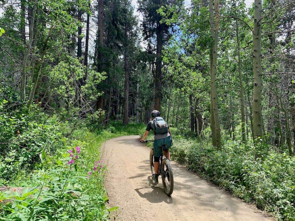
The ride starts out on the Tahoe Meadows trail with a spin through a beautiful meadow before ducking into the forest for 8.5 miles of rolling singletrack with glimpses of Lake Tahoe to the right.
There are a few tight rocky sections that may need to be walked, but overall it’s a really nice and mellow pedal with only about 1,000ft of climbing over almost 9 miles.
**Note that this is a super popular section of trail along the Tahoe Rim Trail (TRT), so if you’re riding it on an (even) weekend day expect it to be pretty busy.
Tunnel Creek Rd. To Marlette Rd.
This section has the biggest climbs of the ride. After crossing Tunnel Creek Rd., you’ll pedal for a bit before starting up a switchbacked climb that will eventually take you to the incredible Marlette Lake Vista.
The first climb is pretty mellow, it just goes on for a couple of miles and gains about 1,200ft (and remember, you’re already at around 9,000ft!). You’ll descend for a bit, and then it’s time for climb part two. The second climb isn’t as steep or long, but you’ll still be glad to make it to the top.
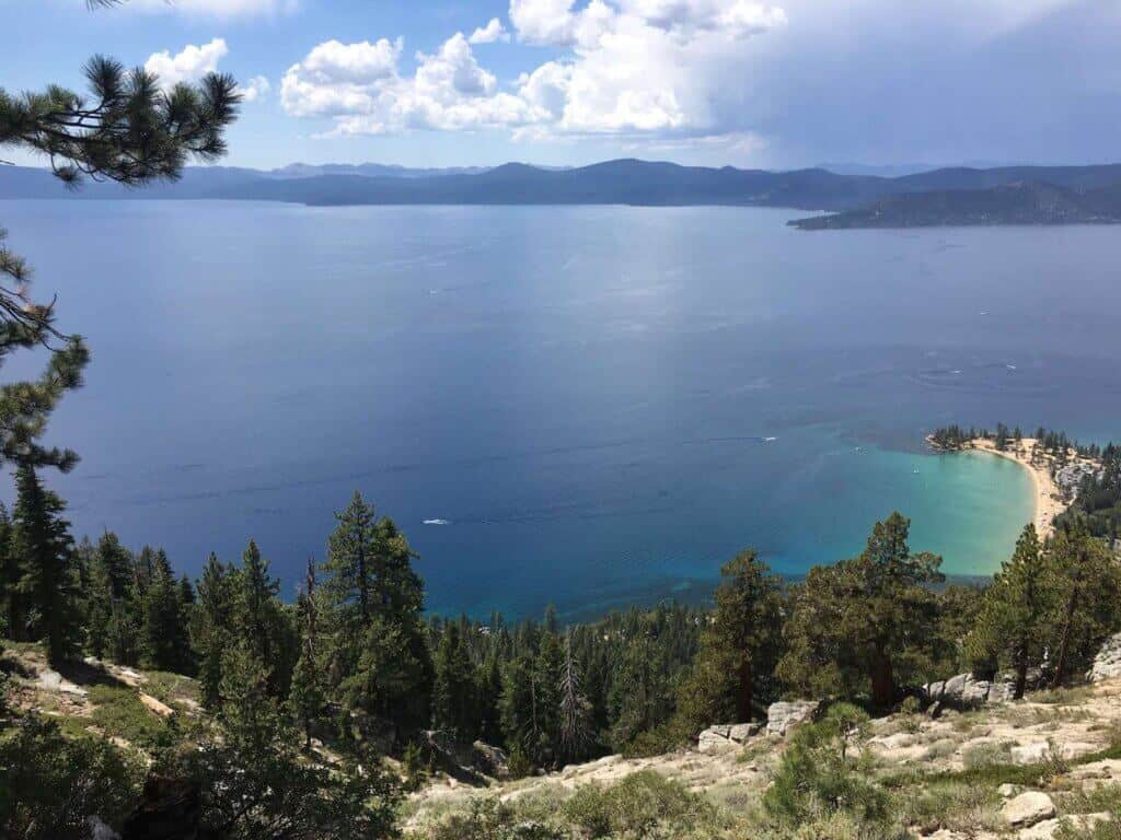
After exiting the forest, you’ll see Marlette Lake and Lake Tahoe to the right. The viewpoint from above Marlette Lake is amazing and a great spot for lunch!
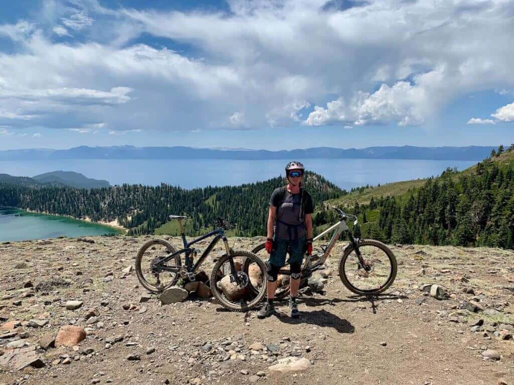
After a break and some food, bomb down the descent. You’ll come to an intersection, which is easy to miss since you’ll be going fast. The turnoff is a hard left. You can go either way at the fork, but the IMBA Epic route is to stay left at the intersection where you’ll pass through a campground.
If you miss the turn and head straight onto Marlette Peak Trail it’s not a big deal as you will connect back into the IMBA route albeit with a little extra climbing.
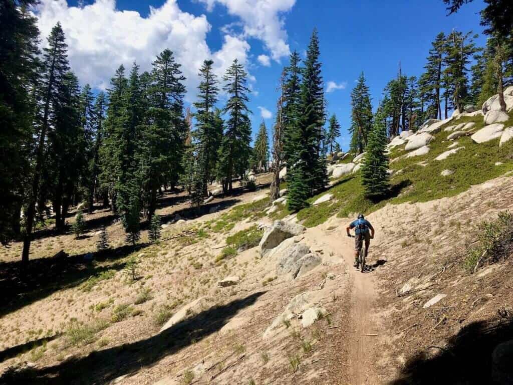
North Canyon Rd./Flume Trail Rd.
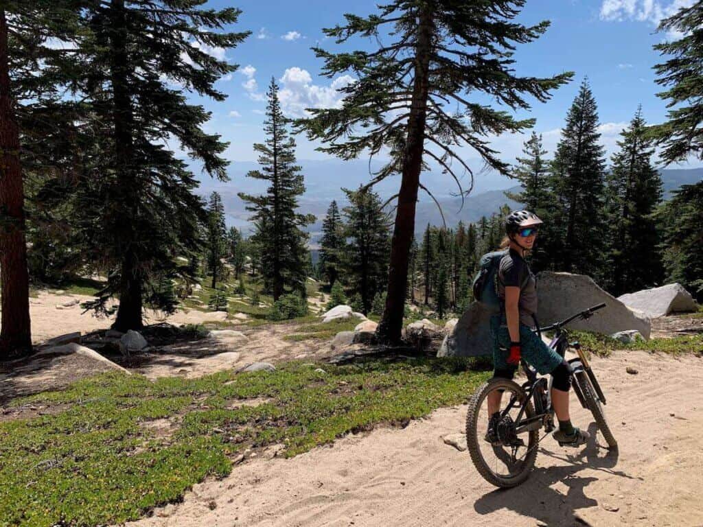
This section of the ride is on a fire road, but it’s actually quite beautiful and a nice, flat pedal. Wildflowers line both sides of the road throughout the spring and summer and if you are riding in the fall, the changing foliage makes this section magical.
You’ll follow the road along the west shore of Marlette Lake for about a mile. There are a few places where you can hop off your bike if you want to cool off with a dip in the lake.
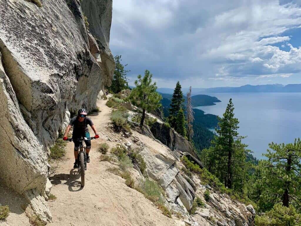
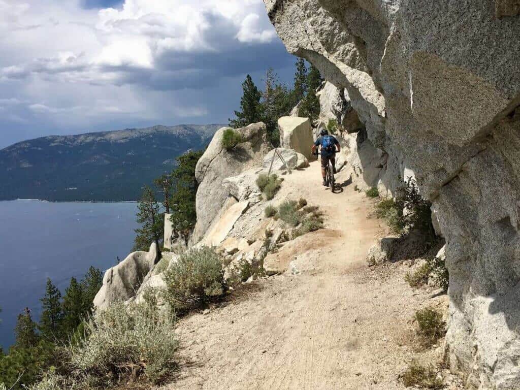
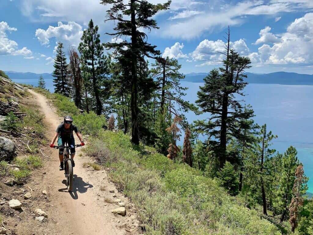
Tahoe Flume Trail
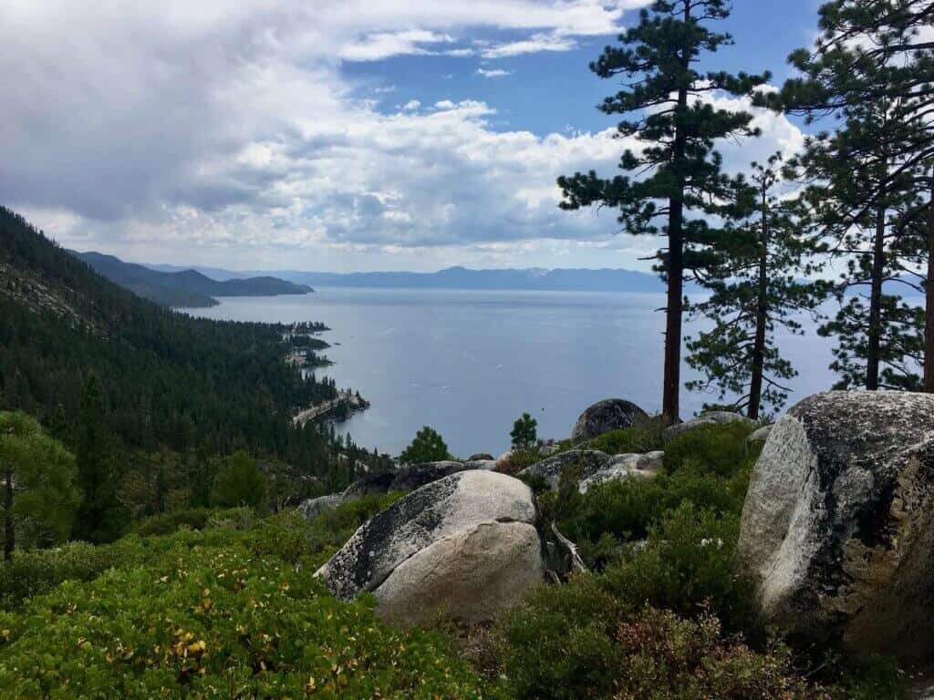
Ok, this is where your jaw will drop. The Tahoe Flume Trail is beautiful. The trail runs parallel to the northeastern shore of Lake Tahoe, but at 1,500ft up above the water so you have a birds-eye view of the lake and mountains in the background. It is stunning.
The only hitch is that parts of the Flume Trail are very narrow with some serious exposure. There are some places you do not want to fall. But the trail itself is mostly flat with little to no tech. Be sure to stop and take lots of pictures!
Tunnel Creek Rd.
The last section of the Tahoe Rim & Flume IMBA Epic is the Tunnel Creek Fire Rd leading to the Tunnel Creek Parking Area, where you should have a car waiting for you (see next section for info about shuttles).
This is a steep double-wide path that is popular with hikers heading up to the Tahoe Flume Trail, so watch your speed and stay wide around corners. It’s downhill all the way.
Alternatively, you could take the Flume Trail all the way up to the Tyrolean Downhill if you still have some juice left in your legs. It adds about 8 miles to the ride and another 800ft of climbing.
Shuttle options
The Tahoe Rim & Flume Trail is a one-way route. It starts at the Tahoe Meadows Trailhead off of Mt. Rose Highway where there is a large parking lot and bathrooms.
Since this is a point-to-point ride rather than a loop you’ll want to leave a car at the endpoint which is the parking area just past Tunnel Creek Cafe in Incline Village. Try to get an early start, because the Tunnel Creek parking area fills up quickly!
If you don’t have two cars and need to arrange a shuttle, Tahoe Flume Mountain Bikes can help you out. They run shuttles on even days and you can book online. Choose the Tahoe Meadows Shuttle to do the full 24-mile Tahoe Rim & Flume Trail ride.
Alternatively, you can choose to just ride the Flume Trail via Spooner Lake, which is about 14-miles long, half of which is on the North Canyon fire road.
Best time to ride The Tahoe Rime & Flume Trail
Depending on how much snow Tahoe receives, the Tahoe Rim & Flume Trail can be ridden as early as June or as late as July. I rode this route in late July and it was perfect. The temps were comfortable and wildflowers were blooming.
Fall is a great time to ride this route as well when the aspen trees are changing color. Depending on the year and snowfall, you may be able to ride through September or even October.
Always check the weather and forecast before heading out on your ride.
What To Bring on your Ride
For a complete list of what mountain bike gear to pack for your trip to Tahoe and Incline Village, head over to my Complete Mountain Bike Trip Packing List and Mountain Bike Pack Essentials posts.
Here are a few essential items for mountain biking the Tahoe Rim & Flume Trail.
Tahoe Rim & Flume Trail Essentials
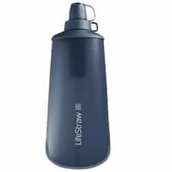
Water Bottle Filter
You can fill up on water at several places throughout the route, but you’ll want to filter it first. The LifeStraw Squeeze water bottle is lightweight and removes 99.9% of bacteria and parasites.
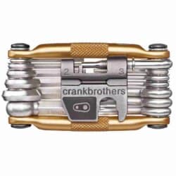
Multi-Tool
A good multi-tool should always stay in your pack, but it’s especially important to have on long backcountry rides. My favorite multi-tool is the Crankbrothers M19
.
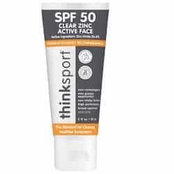
Sunscreen
Definitely pack a small tube of sunscreen for this ride because a lot of it is exposed to the sun. If you want/need extra protection, wear a lightweight long sleeve jersey.
Final thoughts on the Tahoe rim & flume trail
The Tahoe Rim & Flume IMBA Epic is one of the best rides I’ve done in a while. With incredible views, moderate climbing, fun singletrack, and an ending that lands you straight at a cafe that serves tasty food and beer, this ride should definitely be on all mountain bikers’ bike-it list. DO IT!
Have you ridden the Flume Trail in Tahoe or the full IMBA Epic ride? What did you think? What questions do you have? Leave a comment below!
Pin it for later!


Yes, Becky, there’s plenty of parking along Mt. Rose Highway at the Incline Flume Trailhead. If I’m riding with higher level riders we’ll sometimes park a mile lower down the highway at the Old Mt Rose Hwy (Lower) trailhead and ride up to the westerly extension of the Flume trail that connects to the main trailhead shown on Google maps. You can also add an extra 3/4 mile stretch of the flume trail by going west before connecting to the main trail and adding a short unsanctioned trail that goes to the original flume source off of Third Creek.
I like climbing, but I find that riding trails that follow the contour, especially ones on old canals or railroad grades especially intriguing and delightful.
Thanks for the write-up, Becky.
The Marlette Flume Trail is most easily reached by riding out to it on the Incline Flume Trail which doesn’t require a shuttle, long vertical climbs or lots of riding on less fun trails/dirt roads just to reach the good parts. In fact, the Incline Flume trail is just as flowy and fun to ride, albeit without the world-class views.
My wife pushed large stretches when we accessed from the Tahoe Rim Trail from Tahoe Meadows years earlier before the Incline Flume trail was built, but was able to ride the entire Incline Flume Trail except for the short stretch of Tunnel Creek Rd. that connects the two flume trails.
We prefer to ride the two flume trails as an out-and-back for a total of 25 miles of riding when the 1.3 mile flat stretch of road along Marlette Lake is included.
Thanks, Nels, I’ll have to try that! Do you park off Mount Rose Highway?
A definite to do this spring….
It’s pretty epic!