
Trail Guide: Mountain Biking the World-Famous Santa Cruz Flow Trail
Santa Cruz, California – home to the headquarters of Santa Cruz Bicycles – is known for some pretty amazing riding and a cool laid-back vibe.
Perhaps the most well-known trail (at least legal trail) in Santa Cruz is the Santa Cruz Flow Trail in Soquel Demonstration Forest.
Mountain bikers flock from far and wide to ride this trail because it’s one of the best flow trails in the state if not the whole US (not exaggerating!)
Completely machine-built and fast, the Santa Cruz Flow Trail is almost 3.5 miles in length with only 11 feet of elevation gain and nearly 1,300 feet of pure downhill fun.
Sounds amazing, right?
It is pretty darn fun, but there are a couple of things you need to know before heading off to Demo Forest to ride the Flow Trail. Namely, the climbing for the reward…
Read on to get all the info you need to plan a trip out to Soquel Demo Forest! (Sorry about the lack of photos… it’s too fun to stop!).
Getting to Soquel Demonstration Forest
The Santa Cruz Flow Trail is located in Soquel Demonstration Forest about 40 minutes northeast of the town of Santa Cruz.
To get there, take Rt 17 for about 14 miles and turn right onto Summit Rd. Follow Summit Rd. to Highland Way (just keep going straight) until you see the turn-off to the parking area on the right.
There will most likely be a bunch of cars parked on the side of the road.
The parking is free and has plenty of room for dozens of cars. People also park on the side of the road, which is fine too.
It gets really busy on the weekends, so it might take some time to find a spot. Also, note that there have been break-ins at Demo Forest so don’t leave anything valuable in your car.
NOTE: Highland Way Road into Demonstration Forest is long, windy, a bit rough, and washed out in places. But it is all paved. Go slow and turn your headlights on. If you’re afraid of heights don’t look off to the side!
What to Expect
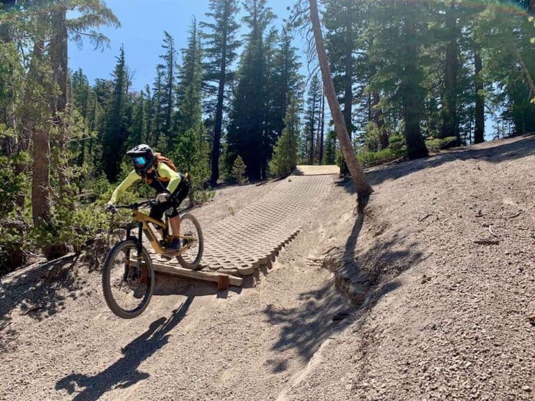
The Santa Cruz Flow Trail is one of the best flow trails I’ve ever ridden. It’s completely machine-built with huge berms, small tabletops, and fast straightaways through beautiful and lush redwood forest.
You can coast the entire 3.4 miles without pedaling a single stroke and there are plenty of opportunities to practice your cornering skills as well as get some small air if that’s your thing.
The Flow Trail is also great for all levels of riders, however climbing up to the top is a bit of a beast, which I’ll get into below.
Watch Ride MTB Express ride The Flow Trail
Important Things to Know
Mountain biking the Santa Cruz Flow trail is awesome, but there are a few things to know before hitting the trail:
How To Ride The Santa Cruz Flow Trail
The main thing to know about the Santa Cruz Flow Trail is that while the 3.4-mile descent is a blast, be prepared to do A LOT of climbing to get the reward.
This is especially true if you plan on doing two laps, which is pretty standard for those heading out to Demo Forest for a day. Some people even pedal three laps, which is just crazy – about 4,350ft climbing.
You can shuttle part of the climb, but there is a gate so you can’t drive all the way up and it’s honestly not really worth the hassle. Shuttling also means you don’t get to suffer with the rest of us…
Getting to the top
There are two main options for getting to the top:
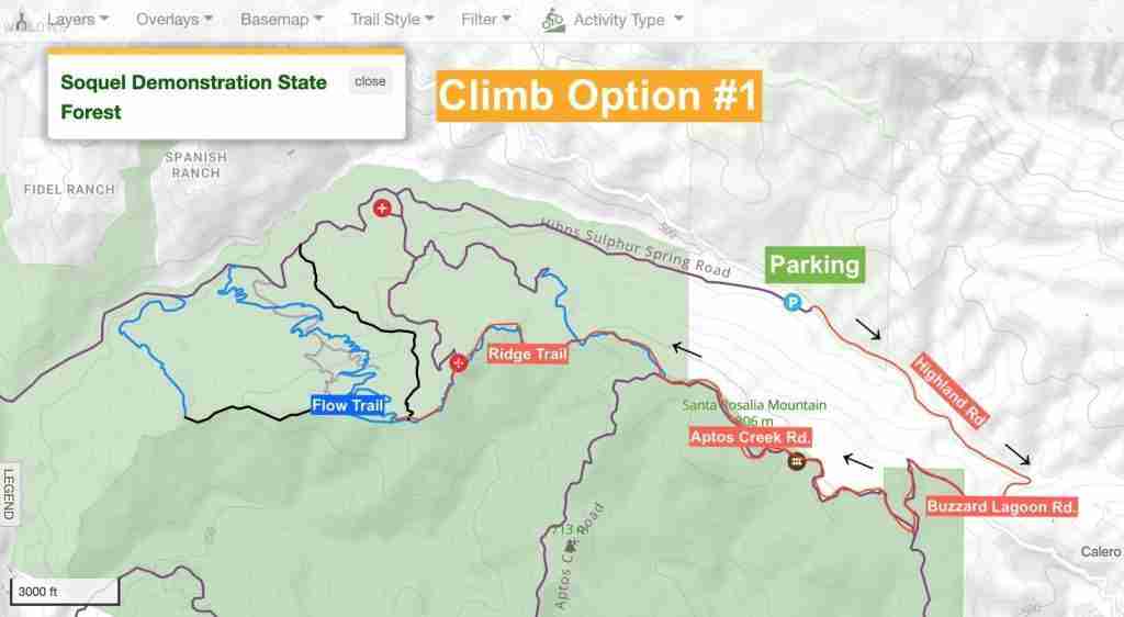
Climb Option #1
7 miles | 1,000 ft +
The main road (Highland Way) > Buzzard Lagoon Road > Aptos Creek Road > Ridge Trail
This is the gentlest way up to the top, but it frankly feels like it takes forever. Start off by turning right out of the parking area onto the paved road and then hang another right at the top of the climb onto Buzzard Lagoon Road. Climb for a bit more on the pavement then turn right onto Aptos Creek dirt road.
Keep going up (there are several turn-offs but just keep going up) until you reach the summit. Then it’s rolling singletrack along Ridge Trail to the start of the Flow Trail.
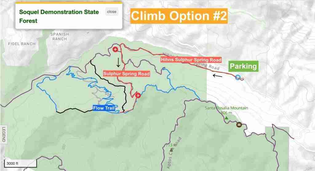
Climb Option #2
1.5 miles | 850 ft +
From the parking area, head down the Hihn’s Mill Road > Sulphur Spring Road > slowly pedal your way to the top
For this climb, the initial roll down Hihns Mill fire road from the parking area has a gentle downward trend, but then you get to the intersection of Sulphur Spring Road and that’s where you start going up. And up. And up… until you reach Ridge Trail.
It’s a hefty climb, but quicker than the first option. For this climb, you skip most of the Ridge Trail, which is actually pretty fun. You can read more about the other trails in Demo Forest below.
Other trails at Soquel Demo Forest
The Santa Cruz Flow Trail isn’t the only trail in Soquel Demo Forest, which surprises some people. There’s also the Ridge Trail and Braille DH.
Learn more about each trail and how to link everything up below.
Ridge Trail
Before dropping into the Flow Trail (or Braille – see below) you’ll be pedaling along the Ridge Trail for about two miles (if you do Climb #1 above. Climb #2 skips most of the Ridge Trail).
There are actually some places that are pretty technical, especially if you’re a newer rider. And, of course, there is also a bit of climbing.
But all-in-all the Ridge Trail is an added bonus to the riding at Soquel Demonstration Forest.
Braille DH
There is a second trail from the top of the ridge called Braille DH. It is completely different from the Santa Cruz Flow Trail.
Braile DH is raw, steep, technical, and has a lot of features including drops and jumps, some of which are very high stakes.
I love both trails – the Flow Trail and Braille DH – but it’s important to know that they are very different.
Braille DH is old-school raw and rough while the Flow Trail is very much new-school smooth and buff. If you ride Braille expect steep, rooty, loose, tight trees, and erosion.
I recommend doing both, but only if you’re an intermediate+ rider.

How to link Everything up
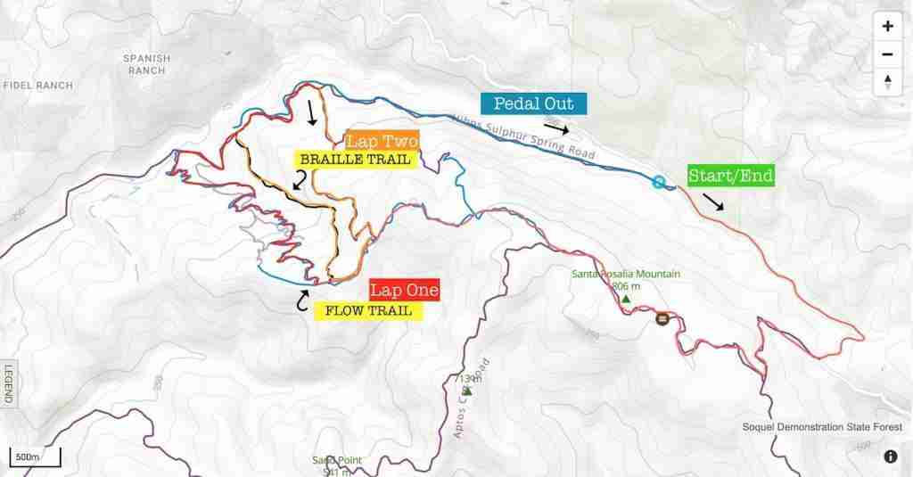
Personally, I think that two laps on Flow/Braille is the best way to experience Demo Forest if you’re up for climbing to the top twice and tackling the old-school sketch on Braille DH.
It’s a 40+ minute drive out there from Santa Cruz, so you might as well make the most of it, right?
Route recommendation
>> Flow/Braille Double Lap
If you’re up for a big day, this double lap at Soquel Demo Forest is my personal fave. Start with a fast, flowy descent down the Flow Trail then hit Braille DH for some more rugged and steep tech.
Route directions: Flow Trail Parking > Right onto Highland Way > Buzzard Lagoon Road > Aptos Creek Road > Ridge Trail > Flow Trail > Hinh’s Mill Road > Sulphur Spring Road > Braille DH > Hinh’s Mill Road
Route notes: You will need lots of water (at least 3 L) and snacks. You won’t be passing through the parking area, so bring everything you need.
Do less: Skip the second lap on Braille DH.
Do more: Seriously?
A few Other things to know
Brake Bumps
The Santa Cruz Flow Trail sees a lot of traffic, so be prepared to hit some brake bumps.
Honestly, though, they’re not nearly as bad as they could be. The trail crew does great work and it’s gotta be challenging to keep up with the wear and tear of this popular trail.
SPEAKING OF TRAIL CREWS
Interested in getting involved? Santa Cruz Mountain Trail Stewardship hosts Dig Days as well as a number of other ways to get involved. Show your appreciation by becoming a member or volunteering. Learn more here!
Trail Traffic
Soquel Demo Forest can get really busy, especially on weekends.
The Flow Trail is great for beginners and families, so don’t be that person who gets all agro about your Strava time.
Be kind, be courteous, be patient, and have fun!
Remoteness & safety
Soquel Demonstration Forest is kinda out there and cell service is mediocre at best.
There are two helipads for emergencies, but always let someone know where you’re going and pack at least a basic first aid kit.
Final thoughts
I hope this guide gives you a better idea of what to expect when you head out to ride the Santa Cruz Flow trail in Demo Forest!
It’s one of my favorite trails, despite the steep climb to the top.
Have fun, be safe, and enjoy!
RELATED POSTS
Looking for some more epic rides in California? Here are a few more of my favorite trails and destinations:
Do you have any questions about the Santa Cruz Flow Trail or Braille In Demo Forest? Have you already ridden it? What did you think? Leave a comment below!


Best description of this trail I’ve found, thank you! Was just there for my first time a week ago and wondering if Sulphur Spring could possibly be the typical way to get back to the top… Sounds like it is! 🙂 Will be adding a second lap next time, if my legs can handle it.
Haha, yes! There’s no great way to get to the top… But the down is worth it! Hope you had a fun run – The Flow Trail is a classic 🙂
Is this open now in early April 2023 with all the rain? used to live there and have ridden it close to 100 times. I need my fix and want to do a road trip. thanks for any help.
Hi Dan – I checked the Santa Cruz Mountains Trail Stewardship website and it looks like Soquel Demo Forest is still closed, unfortunately.
If you take the long climb up and ride the flow trail (it is very fun to ride the ridge trail) however it is a 17 mile ride (per Strava) and longer than we expected after reading this article. There is also about a 4 mile climb out that we didn’t know about and had finished all of our water before getting to it so we were a bit bummed but the climb isn’t bad, not too steep but long and pretty much all uphill. Be prepared for a 17 mile ride though if doing the long climb up and just the flow trail.
If you just do the Flow Trail, the loop is 14 miles. If you do the double lap with with Braille DH, the route is 18 miles.
Thanks a lot Becky for the detailed description of what to expect. It was the only way I could do it on my own. I was there on Wednesday (9/28/22) and followed the route in
Option#1.
Below are a couple of observations:
1. A single loop around the flow-trail was indeed 17 miles with Option-1.
2. I missed the Aptos Creek Rd turnout from Buzzard Lagoon Rd. There are no signs as you mentioned. I took the next turnout to the right from Buzzard Lagoon Road past the “Better Place Forest” entrance which led me to Cusack’s Trail (singletrack, which was quite fun) that ended up connecting to Aptos Creek Road. For a while I thought I was lost.
3. The Ridge Trail is great to warm up before taking the Flow Trail which was an absolute blast!!
4. The ride back to the parking lot after the Flow Trail is brutal. Well its a gentle uphill, but I was totally spent and 4 miles felt like an eternity. I should have carried more water and snacks with me.
5. Demo forest is REMOTE. I rode solo on a Wednesday afternoon, and only saw a total of 3 bikers. Some company is highly recommended.
Thanks for your observations! I plan on updating this post soon, so I’ll stress a few details like the (dreaded) 4-mile pedal back to the car and bringing lots of water.
As far as the distance goes, I’m wondering if the remoteness of Demo forest skews GPS tracking. I’ve done the flow trail three times and each time the single lap has been around 15 miles. I just checked ride logs in TrailForks and Strava and everyone there who’s done single laps records 14-16 miles. There’s definitely some discrepancy. Since it’s mapped out as 15 miles and I’ve recorded it as 15 miles, that’s what I’m going to stick with.
Thanks again for your debrief!
Thanks for the detailed description. I am planning to take my teenage kids there this weekend and this gives me a good idea on what to expect. Cheers and ride on!!
Have a blast!
Great writeup and site. I’ll try out the Flow Trail in Demo Forest tomorrow.
Thanks! Enjoy your day at Demo Forest 🙂
Best type of bike for this trail? Enduro or short travel
If you plan on doing Braille I would go for an enduro/bigger travel bike. If you just want to do the Flow Trail a short travel bike would be great (and also easier to pedal up ;).
Great site and great content! Thank you!
Great description!