| | |

The Baxter Gulch To Green Lake Loop: A Local’s Secret

Share it!
Female mountain biker standing at viewpoint for photo without bike
Mountain bike leaning against trail sign

I’m going to let you in on a little secret. One of the ways I find cool and fun mountain bike rides when I’m traveling is to look at the heat map on TrailForks. Whatever trails get the most ‘heat’ I figure are the most popular and worth doing. So when I was planning my rides in Crested Butte, that’s exactly what I did. Of course Dr. Park and 401 Trail and Crested Butte Bike Park were all lit up bright red, but one route that surprised me, that wasn’t on my radar, was Baxter Gulch to Green Lake.

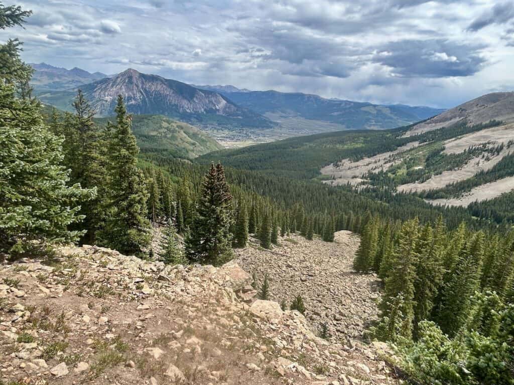
It seemed to get decent bike traffic and after reading the comments and doing a bit of my own research, I put it on my ride-it list. I’m so glad I did! It was a pretty epic ride in all the ways. Epic in climbing (phew…), epic scenery, and epic descent. I really loved it and if you’re the kind of person that loves big backcountry rides with a little (or a lot…) of type two fun, you’ll dig it, too. It seems like a classic Crested Butte mountain bike ride, so if you’re planning a trip to the area, consider putting it on your list. Here’s everything you need to know to plan your day (yes, day) out on Baxter Gulch to Green Lake.

Baxter Gulch to Green Lake at a Glance

  • Location: Crested Butte, Colorado
  • Distance: 14.5 miles
  • Elevation gain: 2,900 feet
  • Elevation loss: 2,900 feet
  • High point: 10,950 feet

Remote backcountry trails, challenging climbs, beautiful forests & views, with a bomber descent

Mountain bikers stopped on sidehill trail to take in the views

What I like about the Baxter Gulch to Green Lake

  • Beautiful views
  • Backcountry vibe
  • Great descent down Green Lake
  • The climb is long, but not too technical

What I don’t

  • Pedaling at 11,000 feet…
  • Green Lake is a bit of a disappointment Apparently I didn’t actually make it to Green Lake! Keep going past the swampy pond and supposedly there is a beautiful alpine “Green Lake”
  • The second half of Carbon Creek is quite rocky and loose and not all that enjoyable (but worth it!)
Mountain bikers climbing a trail through aspen grove

Quick Tips

For riding the Baxter Gulch to Green Lake

  • e-bikes are not allowed.
  • Don’t underestimate the elevation – you top out at almost 11,000 feet!
  • You’re in black bear country. I actually saw one in the meadow at the top of the Baxter Gulch climb. Bring a lunch (and snacks) and at least 3L of water.
  • If you decide to go to Green Lake, the swampy pond is not it. Keep following the trail past the pond and you’ll come to the real Green Lake.
  • Watch out for hikers coming up Green Lake Trail.

TWW Take

Please note that these are my personal opinions – you may argue otherwaaaaise! And if so, state your case (politely) in the comments 🙂

Preparing for your Baxter Gulch to Green Lake Ride

How to ride it

Most people (including me) ride this loop clockwise, climbing up Baxter Gulch and descending Green Lake. I highly recommend doing it this way for maximum fun.

Where to park

Here are the Google Maps directions to the Baxter Gulch trailhead parking. They were actually doing construction there when we did this ride, so we parked across the street at the baseball field, which has bathrooms and water fountains.

Tip: The climb to the top of Baxter Gulch took me about 2.5 hours at a pretty slow pace with some snack and photo stops. Give yourself 4-5 hours (or more) to do this ride.

Trail Map

What to expect

The full loop is about 14.5 miles (including the out-and-back to Green Lake) and about 2,900 feet of climbing. Navigation is pretty straightforward and easy to follow. Here’s what to expect along each section of the route.

Miles 0–6: Baxter Gulch

  • Elevation: Starts at 8,900 ft and climbs to 10,725 ft
  • Terrain: Starts off with smooth, switchbacked climbing and then becomes a bit more technical with rocks and roots. But it’s never too challenging.
  • Vibe: A nice climb through beautiful forest and meadows.
  • Effort: Moderate. It’s never too steep or challenging, but the altitude will make it feel harder.
  • Notes: I really enjoyed the Baxter Gulch climb (at least as much as one can enjoy a six-mile climb at 10,000 feet). The trail starts off with a bunch of switchbacks through aspen groves and then steadily weaves its way up Baxter Gulch to intersect with Carbon Trail. It’s never too steep or technical, but if you’re not used to pedaling at altitude, it will probably feel harder than it should. Just go slow and enjoy the beautiful scenery!

Miles 6-9: Carbon Creek

  • Elevation: Maxes out at just under 11,000 ft
  • Terrain: The first half is actually surprisingly smooth and fast-rolling. After the lookout point (~7.5 miles), it definitely takes a turn to rocky and loose.
  • Vibe: A mostly pleasant traverse with a few climbs and descents, some rocky/chunky stretches, and a great lookout viewpoint.
  • Effort: Moderate+. For being a black-rated trail, I didn’t find it that challenging, although there are definitely some techy sections.
  • Notes: I was expecting this stretch of the ride to be a bit of a sufferfest because it’s rated black on TrailForks and I’d heard that it was pretty rocky and loose and torn up by motos. But I didn’t find that to be the case. The first half was actually quite pleasant – a mellow pedal through beautiful forest up to an awesome lookout point. The second half is definitely rougher with embedded and loose rock, but nothing that I wouldn’t ride again. That last quarter mile to the Green Lake junction was a hike-a-bike for me. It’s technically rideable, but wasn’t worth the effort.

Miles 9-9.5: Up to Green Lake

Update: A friend nicely pointed out that I didn’t actually go to Green Lake. There’s a swampy pond just a few hundred feet below the hidden lagoon that I thought was “Green Lake”. But apparently if you keep going up the trail past this pond, the real Green Lake actually a very nice and scenic alpine lake.

You have the option of doing a 0.6-mile out-and-back to Green Lake or just heading down Green Lake trail from the intersection with Carbon Creek. We chose to go up to Green Lake to have lunch, and while it was nice, it’s not exactly a super scenic alpine lake. I’m glad I did it once, but next time I’d probably skip it.

Mountain bike in front on alpine lake
This isn’t Green Lake… it’s a swampy pond just a few hundred feet below the actual Green Lake
Panorama of alpine lake with mountain bike laying by the shore
The ‘real’ Green Lake | Photo by Carey Kriger

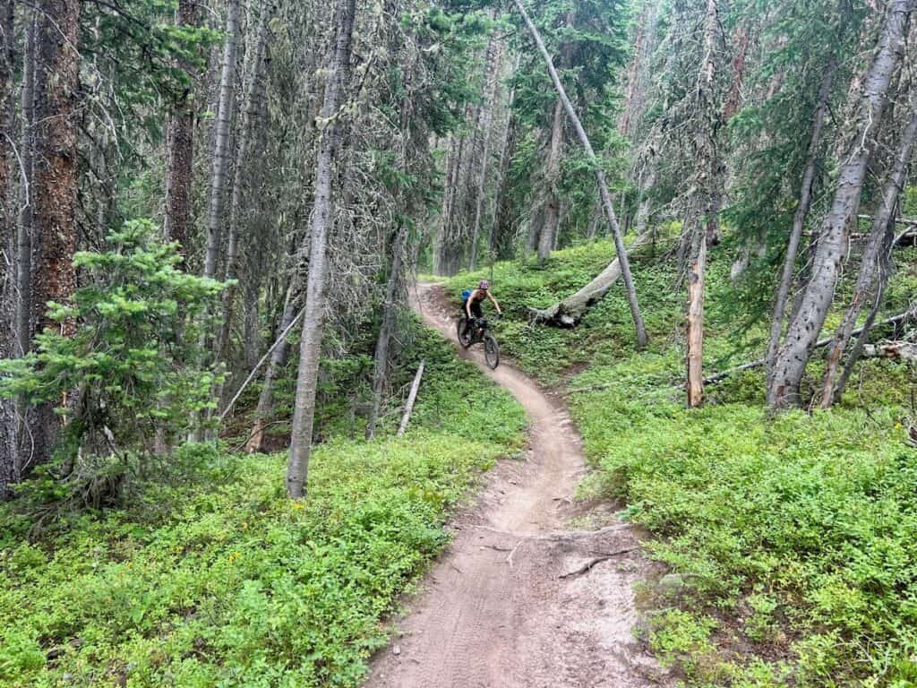
Miles 9.5-13: Green Lake Trail

  • Elevation: Starts at 10,600 ft and ends at 9,030 ft
  • Terrain: Fast and fun! A few rock gardens, but mostly smooth, buff singletrack.
  • Vibe: A great descent through the forest with some tight switchbacks toward the end. It’s over too fast!
  • Effort: Easy. From the top of Green Lake, it’s pretty much downhill the whole way.
  • Notes: I loved this descent! It’s super fast and fun and playful. I was a little worried that it would be chunky and loose because of the last stretch along Carbon Creek, but it wasn’t at all. It was loamy and awesome. The final stretch does have some pretty tight switchbacks, which may be hard for some riders. Also, watch out for hikers coming up Green Lake Trail— we had some close calls.
Mountain biker riding bike on trail through meadow
I didn’t take many photos on the way down because it was so fast and fun and it started hailing!

Miles13-14.5: Journey’s End Road

Green Lake Trail dumps you out on Journey’s End Road, a dirt road that leads back to the main road the trailhead is on. It’s all downhill.

FAQs for riding the Baxter Gulch to Green Lake Loop

Got questions? I’ve got answers! Here are some helpful tips for planning your ride:

No, e-bikes are not allowed on most trails in Crested Butte. Please respect this.

That depends on your pace, but for us, it took about 2.5 hours to do the climb and 4.5 hours to finish the ride (with a moving time of 3 hours 40 minutes).

Honestly, not really. There aren’t any intersecting trails to cut off miles. You could do an out-and-back on Baxter Gulch, but honestly once you get to the top of Baxter Gulch, you don’t have that much more climbing to get over to Green Lake.

We rode the Baxter Gulch to Green Lake Loop in late July, and it was pretty perfect. The wildflowers were going off and the temps were a perfect high 60s/low 70s. Depending on snowpack, you can probably ride these trails from mid-June through late September or early October. I bet it’s beautiful in the fall with the changing aspen leaves.

Yes, but this is a backcountry ride with no cell service. Bring your phone with a trail app downloaded – I use TrailForks, but MTB Project is another option.

No. Once you get a few miles in, you’ll lose cell service until you reach the end of Green Lake Trail.

Need gear recs?

Head over to my gear closet! I’m always testing out new pieces of bike gear and if I really like them, they earn a place on this page.

For a ride that wasn’t even on my radar before visiting Crested Butte, Baxter Gulch to Green Lake turned out to be an awesome find (at least for someone who isn’t a local). The climbing will make your legs and lungs burn, but the mix of forest, meadows, and big views more than makes up for it.

It actually reminded me a bit of the Lost Lake Loop I rode in New Mexico, my favorite kind of route: backcountry, varied, and ending with a beautiful alpine lake that’s perfect for a lunch break.

So If you’re in Crested Butte and want a quieter, off-the-beaten-path ride, this one’s worth adding to your list!

Have you explored the mountain bike trails around Crested Butte? Have you ridden this loop or is it on your ride-list? Leave a comment!

Similar Posts

I love hearing from you and appreciate your comments! However, if you leave a rude, unconstructive, or spammy comment, it will be deleted. It’s cool to be kind. Have an awesome day!

Leave a Reply

Your email address will not be published. Required fields are marked *